As land planners, 7gen starts every project looking at the opportunities and constraints provided by the land along with the related regulating government authorities’ (RGA’s) codes and ordinances. The land’s terrain plays a major role in the project’s design when these opportunities and constraints are considered along with the RGA’s codes and ordinances. Extreme flat or steep slopes increase the challenge of the design. Relocation of dirt, rock, or other land materials and construction of retaining walls and/or extreme building foundations increase construction costs of development. In today’s environment of limited attainable housing costs, development and building costs must be an important consideration when planning a neighborhood.
During the opportunities and constraints analysis of a project, 7gen reviews the project and prepares a slope analysis of the property. Different regions of the country will have different slope categories based on RGA regulations, local area standards of construction, or customer expectations. Houston area projects, for example, tend to be on the flatter end of the spectrum. As a result, homeowners, as well as the builders, expect minimally sloping lots toward the street with no drainage or sheet flow onto their lots. Austin’s hill country region does not have these expectations as the typical slopes are cost prohibitive to provide such lot grading; therefore, the typical residential lot in the Austin area will have some off-site drainage run across the lot. As Houston’s residential development continues to expand to areas further away from current development, both flatter (generally to the south) and steeper (generally to the west, north, and east) terrain is being encountered. Within these steeper areas, it will become cost prohibitive and/or environmentally insensitive to grade as the typical Houston lot is today, and they will have to be designed more like Texas hill country.
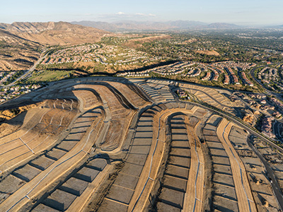
Steep terrain requires that the land planner works with the topography in a variety of ways. As larger lot sizes typically allow for more grading flexibility, I look to place them within the steep areas of the project and smaller lots on the flatter portions. However, the market’s product demand and cost expectations ultimately determine the project’s lot sizes and mix. The market’s demand and project’s terrain does not always match up well. In these cases, additional design methods may need to be utilized, such as placing roads parallel or perpendicular to the slopes. These methods and their application are determined by the slopes, lot size, and product to be delivered. Overall, the design needs to work with the opportunities provided by nature. Forcing a design, especially a grid, on steep slopes, only leads to higher construction costs to achieve buildable lots.
Drainage areas and patterns are other important aspects of working with the terrain. Steep terrain has well-defined and rarely relocatable drainage while flat terrain may lack discernible drainage patterns. As a result, for projects on steep terrain, the areas between the drainage corridors become the potential development areas, while the valleys can potentially be utilized for conveyance or storm water detention. The open space corridors start to define the overall community’s park, open space, and trail network. On the other hand, drainage patterns must be designed into the overall community system for flat terrain, the same way a road system might be considered. This is done by defining the location for the major drainage corridor and working upstream into the community, reducing drainage corridor sizes until they are no longer required to get storm water from streets, and development parcels into the system. The process is very similar to how planners work from major thoroughfare roads to collectors to local streets. Though there is flexibility in the location of the drainage ways, the planner needs to locate them in such a way as to provide good drainage, reduce piping costs, and create an attractive environment for people to live. Flat terrain typically comes with floodplain issues or concerns which will be addressed in a separate blog.
Hopefully, this article provides more insight as to the importance of working with the terrain Mother Nature has given your project, and the value or cost it may bring to your overall community.